Stoberry House
Somerset
| Location | Wells | ||
| Year demolished | c.1959 | ||
| Reason | Derelict, then fire, before final demolition | ||
| << Back to the main list |
Stoberry Park in Wells is approached from the head of College Road or the Bristol Hill (A39). As is the case with many estates, there is a lodge entrance with decorative iron railings marking the start of the carriage drive that leads through the park and a substantial stone tunnel with iron gates, providing access from the Bristol Hill. Stoberry Warren and Stoberry Cottage (now Warren Cottage), the former farm bailiffs and gamekeeper’s residence are also accessed from the Bristol Hill. Yet, today the drive ends without the elegant house which had graced this estate since the eighteenth century.
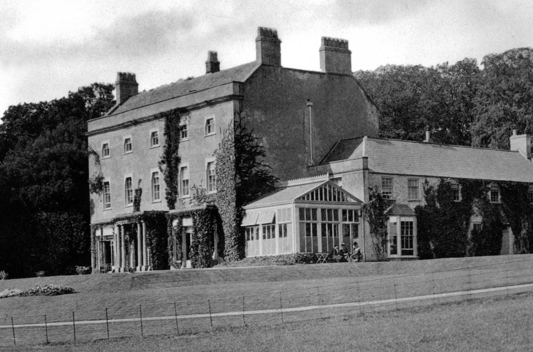 Stoberry House
(Image © unknown)The name "Stoberry" is derived from the earlier medieval fieldname Stabergh, attested in local charters from the thirteenth and fourteenth centuries, itself from Old English 'stan' and 'beorg' - "stony hill" - a description suited to its elevated site north of Wells.
The first house of c.1745 under Peter Davis
The first house was built around 1745 by Peter Davis (1706-1777) in landscaped grounds. This was built on farmland formerly part of East Wells Field. Within the present park there remain traces of lynchets and field systems, leats and stock ponds, and the remains of possible medieval house platforms, all indicative of earlier occupation and re-use of a long-cultivated landscape. Davis occupied the house until his death in 1777.
The 1788 map of the Parish of St Cuthbert shows two distinct buildings, which are likely to have been the house together with stables and farm yard. Some of these outbuildings are believed to survive in altered form, later converted to domestic accommodation in the 1960s.
The rebuilding of c.1796 under Peter Sherston
Davis' estate was inherited by his cousin Peter Sherston (1744/5-1820), who obtained a grant of arms identical to those of Davis and 'built' himself a house around 1796. Photographs taken in 1949 and 1957, preserved in the Historic England Archive suggest that the earlier house may have been retained and altered. These show a Palladian window to the rear, and a simple and symmetrical freestone façade, with a freestone portico in a restrained classical style and decorative fanlight with intricate lead or cast-iron tracery.
Contemporary description survives in Bernard Burke’s A Visitation of the Seats and Arms of the Noblemen and Gentlemen of Great Britain (1852), which states:
"The House, which was built in the year 1796 by Peter Sherston, Esq., stands about a mile to the north of the city of Wells, which it overlooks, its site being upon an eminence. Here too it commands a fine prospect over the vale below, extending as far as the Dorsetshire hills. It has a park appended to it of moderate size, and tolerably well timbered."
Stoberry Lodge at the end of the carriage drive, built in the Cottage Ornée style, and photographed in 1909, was also likely to have been built under the direction of Peter Sherston.
The 1820s improvements to the Stoberry Park Estate under Peter Davis Sherston
Further building is reported to have taken place under Lieut. Colonel Peter Davis Sherston (1783-1834) during the 1830s, although, the extent of works to the house are not known. This could have included the building of the service wings which were complete by 1835 as shown on Richard Creighton's map of Wells of that year. The eastern service wing is shown in an early photograph.
Architectural works from this campaign included building Stoberry Cottage around 1829 which housed the estate's bailiff and gamekeeper. The cottage was built on land that was divided from the rest of the park by the Turnpike Road which was diverted and completed around 1827. The 1837/8 tithe map shows this phase. The cottage survives in altered form.
Later condition and decline
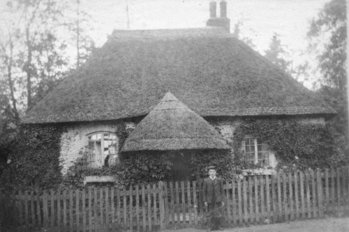 Lodge Cottage c.1909
(Image kindly supplied by Richard Raynsford)By the mid-nineteenth century, Stoberry had assumed the aspect of a classical mansion with a regular plan with attached service wings and landscaped park. The house was large enough to accommodate visiting Assize Judges before official lodgings were acquired in 1843, and its 1853 sale particulars describe a mansion with piped water and water closet, warm air apparatus, attached and detached offices, rookery and walled kitchen garden, terrace walks, and summer house within the neighbouring rabbit warren.
A conservatory and an enlarged western wing were subsequently added, both visible on the 1888 Ordnance Survey map surveyed in 1885 and the conservatory confirmed by an early photograph. The western extension and inclusion of a conservatory suggest a composition that combined late-eighteenth and early nineteenth-century regularity with later nineteenth-century asymmetry.
The estate went into decline towards the middle of the 20th century and the imposing entrance from College Road is marred by the modernisation of Stoberry Lodge, involving the removal of the thatch and features characteristic of the Cottage Ornée style, the removal of the iron gates and houses built in the 1950s and 60s. The iron gates are understood to have been removed in the 1920s following serious floods that damaged the gates of a nearby arboretum, known locally as The Coombe.
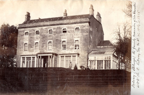 Stoberry House
(From Thomas Serel’s ‘Book on Wells’ in Wells City Archives (WCC/3388). Image © Wells City Council)A summer camp for American troops was established in 1943 on the southernmost part of the park and weather boarded, Nissen and felt and plaster huts were constructed altering this part of the historic park. The camp would later be used for prisoners and in 1945 was classed as a German Working Company Camp. Permanent housing was built on the site in the 1950s and 60s. The 1961 Ordnance Survey shows the prisoner of war camp along College Road, which was later removed and developed into housing and Stoberry Infants School. The later phase of development is shown on the 1968 Ordnance Survey Map.
The photographs in the Historic England Archive show a rapid decline in the condition of the mansion between 1949 and 1957. The house was left empty following the death of the final occupant in January 1956, who was removed to hospital about a month before her death. By 1957, the Somerset County Planning Office listed the house as "threatened." Newspapers described "smashed windows" and the building "left to fall apart." A fire on 15 February 1958 caused "extensive damage to the rear of the house," burning through floors and destroying interior fittings. The remains were demolished early in 1959, with "200 tonnes of demolition hardcore" and "good building stone and rubble" subsequently advertised for disposal.
Today, the site of the mansion is marked by a large pond which is likely to have been formed from the former wine and beer cellars, while the coach yard and walled kitchen garden survive in altered form as part of the current incarnation of Stoberry House and garden and neighbouring properties. The plinths of the columns that supported the portico can also be found on display in the walled garden and traces of the hot houses and vinery are visible on the walls.
Credit: this history is based on the extensive research of Tom Sheppard, who has generously shared his findings and permitted their use on Lost Heritage.